Kerala Weather : Rains may be heavier in the eastern pockets and coastal regions
Due to the cyclonic circulation over the BoB and consequent strengthening of the lower westerlies and the offshore monsoon trough widespread moderate
Kerala Weather : Rains may be heavier in the eastern pockets and coastal regions
Under the influence of the above mentioned synoptic factors,
The deep depression that developed over the BoB around 24 th September unleashed extremely heavy rains in interior Maharashtra, Mumbai, Gujarat, Chattisgarh, Bihar, Jharkhand, the northeastern regions, east Uttarpradesh, Odisha, sub Himalayan west Bengal, and Madhya Pradesh.
In the south, due to the strengthening of the lower level westerlies of monsoon current caused by the low pressure system, Telengana, coastal and interior Karnataka , Konkan & Goa, central & south Kerala and extreme south Tamilnadu received moderate to heavy rains . Isolated very heavy rains battered eastern and coastal regions of south Kerala.
The monsoon trough continues to become weaker with rapid dissipation of the north west heat low over Pakistan and the intrusion of the subtropical upper level westerlies south of the Himalayas.
The line of monsoon withdrawal is currently through Gujarat , west Madhya Pradesh, Uttrakhand and west Uttar Pradesh . Though officially the SWM has ended it's run over India, on a realtime basis the monsoon is expected to completely withdraw around 14 th October and the North - east monsoon is likely to set in simultaneously over southern peninsular India.
Monsoon performance & rainfall data
The monsoon made up some leeway along Bihar and east Uttarpradesh on its last lap aided by the back to back lows. The performance of monsoon continues to be spectacular across the entire country . The overall 81% rainfall received has remained consistent.
Out of the 738 districts 71( 9%) districts comprised in Rajasthan, Gujarat, Uttrakhand, Himachal Pradesh, Punjab, Jharkhand, Telengana and J & K have received large excess rainfall. A total of 9 districts ( 1%) across the country mostly comprising districts in Arunachal Pradesh, Assam, Meghalaya and east Uttar Pradesh have suffered a large deficit in rainfall.
The rest 519 (70%) districts received excess to normal rainfall.
Deoria district in east Uttar Pradesh continued with the highest deficit rainfall of 87% in the country. As against its average normal rain of 73 cms it received just 9.7 cms. Other large rainfall deficient districts are Anjaw in Arunachal Pradesh, south west Gharo hills and west Jiantia hills of Meghalaya . Anjaw district currently runs a deficit of 73%.
As against its normal of 155 cms it received only 42 cms. The south west Gharo district has a deficit of 74% of its normal rainfall . As on date, against its normal rainfall of 183 cms the district received only 47.5 cms. In west Jiantia hills, against its normal rainfall of 442 cms, it has received only 112 cms.
Bageshwar district of Uttrakhand in the Kumaon ranges of central Himalayas continues to top the with a large excess rainfall of 239% . As against its normal rainfall of 79 cms, it received 267 cms as on date. ( rainfall data courtesy IMD)
Western & southern regions
In the western regions, the offshore western trough remained moderately active upto the Kerala coast thanks to the deep depression over the BoB that developed around 24 th September and progressed westwards causing extremely, heavy rains over Madhya Maharashtra Ratnagiri,Marathwada, Mumbai, and Gujarat regions.
In the south, moderate to heavy rainfall occurred in interior Karnataka, Telengana and Kerala between 26 th & 28 th September.
Temperature anomalies
Maximum, temperatures in the north western plains have inched up slightly as the rains have eased up with more sunny hrs.
Avg temperature all over the north Indian plains was around 33°C . In the mountains and tourist spots like Pahalgam and Gulmarg the maximum & minimum temperatures were 25.8 °C and 21.2 °C & minimum at 11°C and 10°C respectively.The highest maximum temperature recorded last week in J&K was at Jammu & Kathua at 35.8 °C and the lowest maximum day & minimum night temperature was at Niyoma in the UT of Ladakh at 20°C & 1.7°C .
As usual the higher mountain pass of Zojila in the UT of Ladakh , situated at an altitude of 3528 metres from mean sea level recorded the lowest maximum of 7°C and a lowest minimum of -4°C.
In Himachal Pradesh the lowest maximum day temperature and lowest minimum night temperature was recorded at Keylong at 24°C & 8°C respectively. Manali recorded a maximum of 25.6°C and a minimum of 14°C , while Shimla recorded a maximum of 27.7°C & a minimum of 16.7°C. The avg maximum temperature for the State was 27.8°C.
In Uttrakhand, the weekly average maximum & minimum temperature in the pilgrim stations of Kedarnath, Gangotri, and Badrinath, Auli , lying in the upper western Gharwal Himalayas, was around 11° C and -2°C respectively.
Among the hillstations in the lower Gharwal western Himalayas in Uttrakhand, lying at an altitude range between 1500 metres & 2900 metres above msl, Kanatal ( 2600 metres above msl) recorded lowest maximum day temperature of 17°C and lowest minimum of 8°C, followed by Mukteshwar at 22°C & 14°C respectively.
Among the other hillstations of Uttrakhand in Gharwal Himalayas lying at still lower altitude, of 2000 ms and below, like Choptha, Chaukori, Chakratha, Dhanaulti & Mussoorie and the hill stations in the Kumaon Himalayas towards the east , like Nainital, Munsiyari, Almora, Pithoragarh , Ranikhet, the average maximum temperature remained on an avg at 23°C and the minimum at 13°C.
In the north east, the Nathu La & Sela passes at above 4500 metres above sea level in Arunachal Pradesh recorded the lowest maximum temperature of 8°C and 10°C & minimum of -2°C & 1 °C respectively and in Yumthang at 3700 ms altitude in Sikkim recorded the lowest maximum at 12°C and minimum temperature of 5°C.
Current conditions & general forecast for the upcoming days
Current observations
The monsoon has weakened substantially with the subtropical upper level westerly jet moving southward of the Himalayas. An upper level anticyclonic cell lies over west Pakistan. The line of SWM withdrawal passes through Gujarat, west Madhya Pradesh west Uttarpradesh and Uttrakhand.
The monsoon trough would decay completely by October 2nd week and conditions would become favorable for the commencement of the north - east monsoon or the retreating monsoon. The Siberian high pressure has already started aligning and consolidating east of Russia. This outbreak signals the wind reversal process as north - easterlies over the Indian subcontinent.
The north west end of the monsoon trough has receded in sync with the intrusion of the subtropical upper level westerly jet and the upper level anticyclonic cell may continue to lie over east Afghanistan and adjoining Pakistan.
With monsoon wind shear further weakening conditions are becoming more favourable for cyclonic activity over the southern peninsular India.
More depressions on the cards
The deep depression which developed last week after causing widespread very rains in interior Maharashtra, Ratnagiri, coastal Maharashtra and south Gujarat may transit with heavy rains over Junagadh, Jamnagar, Ponbander and Dwarka in Gujarat before it moves westwards to the north Arabian sea between 1 st & 3 rd October. The system may recurve back to the Gujarat coast atround 6 th October and may soon peter out.
A fresh cyclonic low is likely over central BoB off the coast of Andhra and Odisha around 1st -2 nd September. The cyclonic low that may develop over central BoB on 1sy October may once again progress westwards causing very heavy rains over Odisha, Jharkhand, Bihar, gangetic West Bengal, Sub-himalayan west Bengal, Chattisgarh, Vidarbha, Madhya Maharashtra, west Madhya Pradesh, east Uttarpradesh, south Rajasthan, Mumbai coastal and Gujarat between 3 rd & 7th October.
Pockets in Bihar like Purnea, Patna, and Darjeeling, Siliguri, Alipurduar , Kalimpong in Sub-himalayan west Bengal, Goalpara, Bongaigaon in Assam, Faizabad, Lucknow, and Gorakhpur in east Uttarpradesh would be hit the hardest by the rains.
As a moderately strong pulse of western disturbance would also prevail concurrently over the north west from 4 th to 6 th October, the cyclonic low may not intensify beyond west Uttarpradesh Pradesh.
On 3 rd and 4 th October widespread very heavy rainfall may be expected in Rourkela, Dhanbad, & Ranchi, in Jharkhand, Kolkata, Kharagpur in gangetic west Bengal, on 4 th & 5 th October in Purnea, Patna, in Bihar, Darjeeling, Siliguri, Alipurduar , Kalimpong in Sub-himalayan west Bengal, Goalpara, Bongaigaon in Assam, Faizabad, Lucknow, and Gorakhpur in east Uttarpradesh .
On 4 th & 5 th very heavy rains may be expected in Raipur , Ambikapur, Korba in Chattisgarh and from 3 rd to 5 th October , very heavy rains may be expected in Jabalpur, Rewa, Bhopal, Khandwa Nainpur in Madhya Pradesh.
Vizag, Vijayawada, Srikakulam , Nandyal & Kurnool in Andhrapradesh and on 4 th & 5 th October and Surat, Bhavnagar , Vadodara, in Gujarat would experience heavy rains from 2/10/25 to 4 /10/25.
North western India
Due to the impact of a fresh pulse of western disturbance embedded in the upper westerlies interacting with low pressure system in the easterlies moderate thundershowers may be expected in Srinagar, Jammu, Ramban, and Kishtwar , Anantnag,& Gilgit in J&K and in Jodhpur Udaipur Dungarpur Kota Bhilwara in Rajasthan from 4 th to 6 th October.
The upper reaches of the Zanskar ranges in J&K may receive mild snowfall on the above dates.
North East regions including gangetic west Bengal, and Sub -himalayan west Bengal
Under the influence of the cyclonic low over central BoB and the strengthening of the lower level easterlies, heavy rains may be expected in Darjeeling, Siliguri, Alipurduar , Kalimpong in Sub-himalayan west Bengal, Goalpara, Bongaigaon in Assam, Kolkata, Kharagpur, upper Assam, & Meghalaya on 3 rd & 4 th th October .
Central India Maharashtra & Gujarat
In central Indian region, under the influence of the cyclonic low very heavy rains are likely in Nagpur , Nanded, Washim, Amaravati , Chandrapur, Balharsha, Akola in Vidarbha, Kolhapur, Nashik, Igatpuri , in Madhya Maharashtra, Ahmednagar, Beed in Marathwada, Mumbai, Goregaon, Dombivli, Roha , Ratnagiri and pockets like Vadodra , Surat Bhavnagar in Gujarat on 5 th & 6th October.
Southern regions
In the south peninsular India, due to the cyclonic circulation over BoB progressing westward , and associated trough extending from Maharashtra to Andhra Pradesh, and an active east west shear zone very heavy rainfall may be expected in Hyderabad , Karimnagar , Ramagundam, Mahbubnagar, Warangal, Khammam & Manuguru in Telangana,Kurnool, Nandyal, Vizag, Vijayawada, Eluru, 4 th & 5 th October
In Karnataka, due to a north south shear zone, extending from Madhya Maharashtra to south Tamil Nadu, through Karnataka the north interior pockets of Bellari, Gadag, Hubbali, may get moderate to heavy thundershowers or rains on 3 rd October. Bengluru and its suburbs may get light to moderate rains on 3 rd & 4 th.
In Tamil Nadu, due to an upper air circulation and moisture flux convergence and leeward troughing over interior Tamilnadu Chennai , Kanchipuram, Tindivanam, Puducherry, Ariyalur, Perambalur, Dindigul , Tanjavur, Trichy, Salem, Madhurai, Vadippatti and Ramanathapuram may expect isolated heavy thundershowers on 3 rd evening or late night & on 4th October the rains would be in Rajapalayam, Tenkasi, Kovilpatti and Coimbatore regions.
North East Monsoon
With the lower level north easterlies commencing on 14 th October, signalling the arrival of the north east monsoon, interior Tamilnadu, particularly, Coimbatore, Salem, Dindigul, Tiruppur and south Tamilnadu may expect heavy thundershowers or rains on 13 th ,14 th & 15 th October.
In Kerala after a brief burst of active mode, the offshore western monsoon trough may lie low or may be indiscernible as the general monsoon circulation has weakened over the country. Therefore not much rainfall activity is likely in Kerala from 2 nd October except isolated thundershowers over eastern pockets of central & south Kerala on 3 rd October.
However with wind reversal happening towards the 2 nd week of October, the SWM may withdraw by 14 October and the lower level north - easterlies would set in simultaneously over Kerala and Tamil Nadu. Heavy thundershowers may be expected in all eastern pockets and in south Kerala on 13 th & 14 th October.
All India regionwise rainfall forecast
Union territories of J& K and Ladakh
Moderate rains or thunder showers may be expected in Srinagar, Kishtwar, Sambar, Padum, Kathua, Udhampur, Anantnag, Ramban region from 4th to 6 th September due to a fresh pulse of western disturbance embedded in the upper westerlies and an associated trough. As usual the upper reaches of Kargil and Skardu in the Zanskar ranges may expect mild snowfall.
NCR Delhi, Punjab and Haryana, Uttrakhand and Himachal Pradesh
As the monsoon has withdrawn from major areas of the north west, now the upper westerlies may gradually take control and the impact of western disturbances may start with light rainfall activity over the NCR on 5 th & 6 th, Pockets in Punjab and Haryana and in Himachal Pradesh, moderate to heavy spells of thundershowers may be expected on 6 th October.
The north- east, , Gangetic west Bengal, Odisha and Sub-himalayan west Bengal regions
Under the influence of the cyclonic circulation lying over central BoB and consequent strengthening of lower level easterlies, moderate to heavy rains are likely in Alipurduar, Darjeeling, Gangtok Kalimpong in Sub-himalayan west Bengal regions on 3 rd & 4th October.
Bihar & Jharkhand
Due to the cyclonic circulation over central BoB , moving westwards, isolated heavy rainfall may be expected in Patna, Darbhanga , Sasaram Purnea & Gaya in Bihar and in Rourkela , Ranchi in Jharkhand on 3rd and 4th October..
The cyclonic low progressing westward and the associated trough extending from north interior Maharashtra to Telengana, may cause very heavy rainfall in Madhya Maharashtra & Ratnagiri regions. Hence, Jabalpur , Rewa, Itarsi, Khandwa, Indore & Nainpur in Madhya Pradesh, Nagpur , Nanded, Washim, Amaravati , Chandrapur, Balharsha, Akola in Vidarbha, Kolhapur, Nashik, Igatpuri , in Madhya Maharashtra, Ahmednagar, Beed in Marathwada, Mumbai, Goregaon, Dombivli, Roha , Ratnagiri and pockets like Vadodra , Surat Bhavnagar in Gujarat on 5th & 6 th September.
Andhra Pradesh, Telengana and Karnataka , Kerala & Tamilnadu
Under the influence of the low over central BoB and the associated trough extending from Madhya Maharashtra to Telengana heavy rains are likely in pockets like Hyderabad, Khammam, Ramagundam, Manuguru & Warangal in Telengana and in Vijayawada , Kakinada , Kurnool , Nandyal, & Vizag in Andhra Pradesh, on 4th ,& 5 th September.
In coastal south Karnataka, eastern pockets of Manglore like, Sullia, Coorg, Chikmagalur from 2 nd to 4th October..
Kerala
In Kerala not much rainfall activity is likely except isolated moderate thundershowers in the eastern pockets of Kozhikode, Wayanad, Idukki & Pathanamthitta on 3 rd & 4 th October.
However, towards the second week of October, the lower level north easterlies are likely to set in signalling the arrival of the north east monsoon over Kerala and Tamil Nadu.
Isolated heavy rains are likely over Chennai , Kanchipuram, Perambalur, Tindivanam, Trichy Salem, Trichy, Dindigul, Madhurai , Ramanathapuram, Puducherry, on 3 rd October and in Rajapalayam Tenkasi , Kovilpatti , Sattur, Coimbatore & Salem on 4 th and from 13 th to 15 th October.
Valparai, the western flanks of Nilgiris , Theni and Tenkasi would also receive moderate rains on the above dates .
Heavy rainfall alert region wise.
Rajasthan, Gujarat, & Madhya Pradesh
Under the influence of the interaction between the cyclonic circulation and the associated low pressure system progressing westward from BoB and an active moderate western disturbance, moderate to heavy rains may be expected in Sri Ganganagar, Jodhpur, Bikaner , Ajmer, Kota, Dungarpur, in Rajasthan on 6 th October, and moderate to heavy rains in Indore, Itarsi, Ratlam , Rewa, Bhopal in Madhya Pradesh on 5 th & 6 th October . In Gujarat, Bhavnagar, Vadodara, Valsad, Ahmedabad, Mehsana & Surat may get moderate rains from 5 th to 7 th October.
NCR DELHI, HARYANA & PUNJAB
No very heavy rain alert except , moderate showers in Sangrur, Ludhiana, Bhatinda, Gurudaspur & Patiala in Punjab on 6 th October due to a moderate western disturbance . New Delhi and adjoining areas may get light rains on 6 th and may remain sunny on other days.
East and West Uttar Pradesh
Due to the passage of low pressure system originating over the BoB around 1st October, , Prayagraj, Gorakhpur, Faizabad , Lucknow , Kanpur, & Bareilly may expect moderate to heavy rainfall from 3 rd to 5 th October .
A mild and moderate western disturbance that may lie at upper levels on 4 th October may cause rains or thundershowers over Jammu, Srinagar , Baramulla, Kathua, Udhampur, Padum, Kishtwar & Ramban may expect moderate rainfall on 5 th & 6 th October The higher reaches of Zanskar mountain ranges may receive light snowfall on these dates.
Uttrakhand & Himachal Pradesh
Uttarkashi, Chamoli Gopeswar, Pauri Gharwal ranges, Bageshwar, Mussoorie, Dehradun may get moderate rains on 5 th & 6 th October under the influence of a cyclonic low pressure system that may move westwards from BoB and interaction with the western disturbance.
Gangetic west Bengal, Sub Himalayan west Bengal, Bihar & Jharkhand. Moderate to heavy rains likely in Alipurduar, Darjeeling, Sikkim, Kalimpong in Sub-himalayan west Bengal regions.
on 27 th & 28 th September and in Patna, Darbhanga , Sasaram Purnea & Gaya in Bihar and in Rourkela , Ranchi in Jharkhand from 4 th th and 6 th October.
Isolated heavy rains may be expected in Guwahati, upper Assam regions and Meghalaya and Dibrugarh from 5 to 8 th October.
Maharashtra, Konkan & Goa
Under the influence of the deep depression and the associated cyclonic circulation the may proceed from the BoB westwards moderate to heavy rainfall may be expected in Madhya Maharashtra & Ratnagiri region, Nagpur , Nanded, Washim, Amaravati , Chandrapur, Balharsha, Akola in Vidarbha, Kolhapur, Nashik, Igatpuri , in Madhya Maharashtra, Ahmednagar, Beed in Marathwada, Mumbai, Goregaon, Dombivli, Roha , Ratnagiri from 2 nd to 4 th October.
Chattisgarh & Odisha
Very heavy thundershowers or rains may be expected in Korba, Ambikapur Raipur and in Kamakhyanagar, Narsinghpur Bhubaneswar & Sambalpur in Odisha from 2 nd to 4 th October due to the cyclonic circulation associated with the deep depression over the BoB.
Telengana & Andhrapradesh region
Under the influence of the cyclonic circulation and associated north- south shear zone, very heavy thundershowers or rains may be expected in Hyderabad, Khammam, Ramagundam, Mehbubnagar Manuguru & Warangal in Telengana and in Vijayawada , Kakinada , Kurnool , Nandyal, Muchlipatanam & Vizag in Andhra Pradesh, between 2th & 5 th October.
Under the influence of the deep depression associated with cyclonic circulation that may pass westwards from the BoB,
pockets in north interior Karnataka like Bidar, Bagalkot, Kalburgi, Vijaypura, Hubballi may receive moderate to heavy rainfall from 2 nd to 4 th & Ocober and In coastal south Karnataka, eastern.pockets of Manglore like, Sullia, Coorg, Chikmagalur may receive moderate to heavy rainfall from 2nd to 4 October due to the strengthening of the lower westerlies and the offshore monsoon trough due to the cyclonic circulation.
Under the influence of the cyclonic circulation over BoB and the associated north- south shear zone extending from Madhya Maharashtra to south Tamil Nadu, heavy thundershowers may be expected in Chennai, & suburbs, Kanchipuram , Perambalur Vellore Thiruvannamalai Trichy, Dindigul, Madhurai , Ramanathapuram, Puducherry, Karaikudi from 3 rd to 5 th & from 13 th to 15 th October.
Valparai, the western flanks of Nilgiris , Theni and Tenkasi would also receive moderate rains from 3 rd to th 5th and from 13 th to 15 th October.
Due to the cyclonic circulation over the BoB and consequent strengthening of the lower westerlies and the offshore monsoon trough widespread moderate to heavy spells of thundershowers or rains likely in eastern pockets of Kannur, Kozhikode, Wayanad Idukki ,coastal pockets of Kannur , Kozhikode , Trissur , Ernakulam & Alappuzha and in Kottayam, Pathanamthitta, Kollam & Thiruvananthapuram.
from 3 rd th to 5 th September
Rains may be heavier in the eastern pockets and coastal regions of Kasaragod, Kannur and Ernakulam. Towards the beginning of the second week of October, with the onset of north east monsoon likely, heavy thundershowers may be expected in the eastern pockets of Kozhikode , Malappuram, Palakkad, Idukki, Ernakulam , Trissur, Kottayam Pathanamthitta, Kollam & Thiruvananthapuram from 13 th October.
SPECIAL WEATHER ALERT FOR Pilgrim TRAVELLERS AND TOURISTS
North East India & sub-Himalayan west Bengal( Intermittent rains on all days from 1 to 3 rd October in Darjeeling, Siliguri and Gangtok, Shillong . Maximum and minimum temperature: 24°C & 17°C in Darjeeling and 22°C and 16°C in Gangtok, Shillong.
The hill stations in Pauri Gharwal Himalayas may expect wet weather on 6 & 7 th due a moderate western disturbance interacting with the easterly low. Uttarkashi, Dehradun, Musdourie may get heavy bouts of rain on tgese days. Maximum day temperature 24°C to 26°C and minimum 15°C to 17°C in lower Himalayas and 12°C and 8°C in the greater Himalayas lying above 2500 metres above MSL.
The Kedarnath , Badrinath , Gangotri hill shrines in the Gharwal Himalayas may get wet weather on 6 th & 7 th October . Maximum day temperature in Kedarnath is likely to be 11°C and minimum -2°C and in Badrinath the maximum day temperature is likely to be 11°C and minimum at -1°C . The Hemkund Sahib Gurudwara , as usual , would remain very cold with the maximum day temperature would be 9°C and minimum may range from -2°C to -3°C. Expect rain and light snowfall on 6 th and 7 th October.
Himachal Pradesh
Due to interaction of western disturbance in the upper level westerlies with the trough associated with the cyclonic circulation moderate to light rains may be expected Dharamshala , Chamba, Kangra, Dalhousie in the Dhauladhar ranges and in Manali on 5 th, 6 th & 7 th October.
Maximum day temperature is likely to be around 17°C and minimum around 10°C in upper reaches above 3000 ms sea level. Manali may be wet on 6 th & 7th October and the maximum and minimum temperature expected to be 25°C and 13°C respectively . Shimla may also remain wet with moderate to very heavy rains likely on 6th & 7th September.
Maximum day temperature may be around 24.6°C and minimum around 16°C . The upper northern reaches of Kinnaur ranges and the Sutlej Valley , would continue to be the coldest tourist station in Himachal Pradesh with a daytime maximum around 16°C and a minimum of 4°C to 6°C.
The hill station of Ooty may experience overcast skies with light to moderate spells of rain on 3 rd October and partly cloudy on other days. Maximum day temperature likely to be 18°C and minimum around 13° C.
Kodaikanal may remain partly cloudy with moderate to heavy thundershowers or rains on 3 rd & 4 th & on 13 th & 14 th October. The maximum and minimum temperature may be 21.4°C and 12°C respectively. The upper shola ranges may record lower maximum & minimum
In Kerala the main hill stations of Wayanad , Vagamon , Marayur and Peerumade may receive maximum day temperature around 26°C. In Munnar, spells of moderate to heavy thundershowers or rains are likely on 3 rd & 4 th October with a maximum day temperature around 21°C and minimum around 17°C. Devikulam and in upper Vaguvarrai and Chenduvarai hills the maximum day temperature may settle around 20°C and minimum may be around 16°C .
In other hill stations lying at 500 m to 1000 ms above sea-level the maximum day temperature may be at 28°C and minimum at 20°C . These hillstations may also be rainy on 3 rd & 4 th 13 th & 14 th October. Kanthalloor , Vattavada regions lying may wet weather on 4 th October and generally clear to overcast skies on all other days.
The maximum temperature is likely to be 19°C and minimum temperature may be in the range 13°C- 15°C. Marayur which falls in the rain shadow leeward side of Munnar hills, but being at a lower altitude of 800-1000 ms may be warmer with a maximum around 26°C - 27°C and minimum at 19°C , with chances of light to moderate rains on 4 th October. Heavy thundershowers may be expected in Munnar, Devikulam Peerumade, and Vagamon on 13 th & 14 th October.
The backwaters in Ernakulam , Alappuzha and Kumarakom may experience wet weather. Moderate to heavy spells of rains or thunder showers may be expected on 3 rd and 5 th and on 13 th & 14 th October . The maximum day temperature likely to be 32°C and minimum at 25°C. Global weather outlook .
MJO IOD & ENSO
The intraseasonal MJO continues to be incoherent and weak and is presently meandering in its phases 8 & 1 in the western hemisphere. However ensemble models favour its renewed amplitude and eastward propagation around mid October over Indian ocean. This could give an initial spike to the winter monsoon
Negative IOD prevails and is projected for autumn & winter with negative SST anomalies & cool water upwelling observed over the east African coast and warmer SST over Maritime eastern Indian Ocean.
On the ENSO front, LaNina foot footprint has emerged over the Nino 3.4 with steady drop in the SST to below the -0 5°C threshold. LaNina probability is above 70% between October and December & likely to ease up thereafter to neutral ENSO.
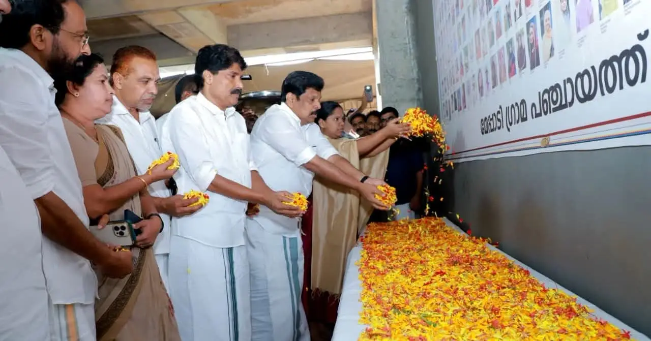
കാലാവസ്ഥാ നിരീക്ഷണവും ദുരന്തപ്രതികരണവും ശക്തിപ്പെടുത്തും: മന്ത്രി ടി. സിദ്ദീഖ്
പുൽപള്ളി പഴശ്ശിരാജ കോളേജിൽ സ്ഥാപിക്കുന്ന ഡോപ്ലർ റഡാർ (Doppler Radar) സംവിധാനത്തിലൂടെ വയനാട് ജില്ലയിലെ കാലാവസ്ഥാ നിരീക്ഷണം കൂടുതൽ കൃത്യവും കാര്യക്ഷമവുമാക്കാൻ കഴിയുമെന്ന് കൃഷി വകുപ്പ് മന്ത്രി അഡ്വ. ടി. സിദ്ദീഖ് പറഞ്ഞു. പുത്തുമല ഹൃദയഭൂമിയിൽ സംഘടിപ്പിച്ച അനുസ്മരണ പരിപാടിയിൽ സംസാരിക്കുകയായിരുന്നു അദ്ദേഹം.
ഡോപ്ലർ റഡാറിലൂടെ മുൻകൂർ മുന്നറിയിപ്പ്(Early Warning System)
പ്രകൃതി ദുരന്തങ്ങൾ മുൻകൂട്ടി തിരിച്ചറിയാനും അതനുസരിച്ച് സമയോചിതമായ നടപടികൾ സ്വീകരിക്കാനുമുള്ള സംവിധാനങ്ങളാണ് സർക്കാർ നടപ്പാക്കുന്നതെന്ന് മന്ത്രി പറഞ്ഞു. കാലാവസ്ഥ മോശമാകുന്ന സാഹചര്യങ്ങളിൽ സുരക്ഷിത കേന്ദ്രങ്ങളിലേക്ക് മാറ്റി താമസിപ്പിക്കേണ്ട ആളുകളുടെ മാപ്പിങ് (Mapping) നടത്താൻ ബന്ധപ്പെട്ട ഉദ്യോഗസ്ഥർക്ക് നിർദേശം നൽകിയിട്ടുണ്ടെന്നും അദ്ദേഹം വ്യക്തമാക്കി.
അതിജീവന പദ്ധതികൾക്ക് കൂട്ടായ പ്രവർത്തനം(Rehabilitation Efforts)
ദുരന്തബാധിതരായ കുട്ടികളുടെ തുടർപഠനം മുടങ്ങാതിരിക്കാൻ ആവശ്യമായ നടപടികൾ സ്വീകരിച്ചതായും മന്ത്രി പറഞ്ഞു. ത്രിതല പഞ്ചായത്ത് ജനപ്രതിനിധികളും ഉദ്യോഗസ്ഥരും വിവിധ വകുപ്പുകളും ഒറ്റക്കെട്ടായി പ്രവർത്തിക്കുന്നതിലൂടെയാണ് അതിജീവന പദ്ധതികൾ (Rehabilitation Projects) ഫലപ്രദമായി മുന്നോട്ട് പോകുന്നതെന്നും അദ്ദേഹം കൂട്ടിച്ചേർത്തു.
അതേസമയം ദുരന്തബാധിതരുടെ വായ്പകളുമായി ബന്ധപ്പെട്ട വിഷയങ്ങളിൽ അനുഭാവപൂർണമായ തീരുമാനം ഉണ്ടാകുമെന്ന് മന്ത്രി അറിയിച്ചു. ദുരന്തത്തിൽ തകർന്ന ആരാധനാലയങ്ങളുടെ പുനരുദ്ധാരണത്തിനായും ആവശ്യമായ നടപടികൾ സ്വീകരിക്കുമെന്നും അദ്ദേഹം പറഞ്ഞു.
ആത്മവിശ്വാസത്തോടെ മുന്നോട്ട് പോകണം(Message of Hope)
ദുരന്തത്തിന്റെ തീരാത്ത വേദന അനുഭവിക്കുന്ന ജനങ്ങൾക്ക് ആത്മവിശ്വാസം പകരാനും അവരെ കൈപിടിച്ചുയർത്താനും കഴിയുന്നതെല്ലാം ചെയ്യാൻ എല്ലാവരും ഒരേ മനസോടെ മുന്നോട്ടുപോകണമെന്നും മന്ത്രി ടി. സിദ്ദീഖ് ആഹ്വാനം ചെയ്തു.
English Summary : In a major move to bolster climate resilience and disaster response in Wayanad, Kerala Minister Adv. T. Siddique announced the installation of an advanced Doppler Radar System at Pazhassi Raja College, Pulpally.