INDIA WEATHER : PAN INDIA WEATHER SNAPSHOT
The past week witnessed a marked revival of the Southwest Monsoon across much of the country.
PAN INDIA WEATHER & SOUTHWEST MONSOON UPDATE
Weekly Outlook: 23–29 July 2026
By Kerala Weather Man
━━━━━━━━━━━━━━━━━━
🇮🇳 PAN INDIA WEATHER SNAPSHOT
━━━━━━━━━━━━━━━━━━
The past week witnessed a marked revival of the Southwest Monsoon across much of the country. As anticipated in last week’s outlook, the Bay of Bengal monsoon depression and the associated mid-tropospheric cyclonic circulation strengthened the monsoon flow over Central, Eastern, and Northwestern India.
The monsoon circulation has now entered one of its most active phases of the season, with widespread heavy rainfall extending from Central India to the Western Himalayas.
━━━━━━━━━━━━━━━━━━
🌧️ RAINFALL HIGHLIGHTS
(16–22 July)
━━━━━━━━━━━━━━━━━━
Rainfall improved modestly during the week but remained below the long-term seasonal average. Several central and northern districts continued to record rainfall deficits, reflecting the relatively weak low-level monsoon westerlies reaching the Western Ghats. The offshore monsoon trough remained active from Gujarat to the Malabar coast. As on date the deficit in Kerala is at 35% based on long period average. As against a total of 114 cms Kerala has logged only 73 cms with biggest deficit of over 60% in Idukki and Wayanad. All districts except Trivandrum have run up a deficit of over 20% while among the deficit districts, Kollam , Ernakulam, Alappuzha, Palakkad, Trissur, & Malappuram suffered above 30% deficit. The normal rains in Trivandrum is of no solace and use as Thiruvananthapuram gets the least amount of rains in the south west monsoon due to the low altitude of the western ghats and the relatively northern position of the offshore monsoon trough which totally avoids the southern districts of Thiruvananthapuram & Kollam.
Major portions of Tamil Nadu fall in the rain shadow region with just about a normal rainfall of as little as 10- 15 cms and on the whole Tamil Nadu has received normal rainfall. However , the western parts of Nilgiris , Valparai, Coimbatore and the Pothigai hills on the eastern flanks of Thirunelveli district, which span the windward crest of the western ghats get more rainfall compared with other regions of Tamil Nadu. In fact certain pockets in Valparai in Coimbatore district and Avalanche in the Nilgiris , the upper Kothayar and Singapatti, in the Selvalar -Manjolai hills in Tirunelveli receive rainfall as high as 150-200 cms during south west monsoon alone
Rainfall increased as the offshore trough gradually strengthened, with moderate to heavy spells reported along the coast.But here too the deficit is above 30 %.
The interior Karnataka is a rain shadow region except the Chikmagalur , Coorg and Hassan districts which have major portions abutting the western ghats causing higher rainfall. The other eastern regions which usually gets its normal rains in the range of 20-30 cms have a deficit of over 25%.
🌾 Andhrapradesh , 🌾 Telengana
In Andhra Pradesh & Telengana rainfall is nearly normal .
A significant increase in rainfall was observed across interior Maharashtra under the influence of a northwestward-moving mid-tropospheric monsoon low.Heavy to very heavy rainfall was reported over several districts in Vidarbha region.
The monsoon became highly active over Madhya Pradesh.
Very heavy rainfall has been recorded in the following stations..
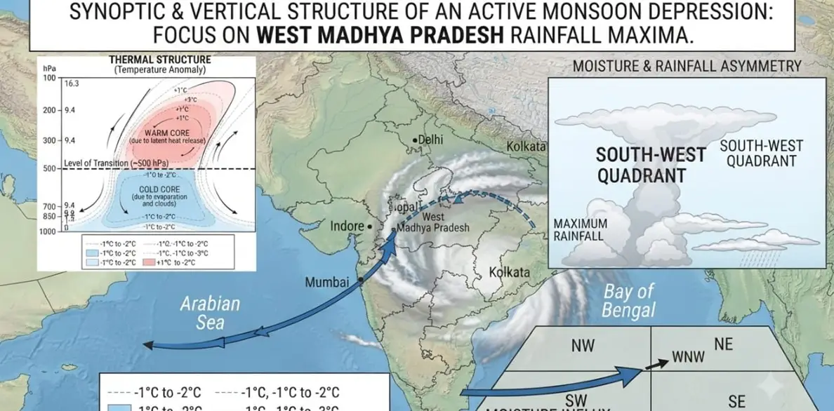
and adjoining districts as the monsoon low tracked northwestward. As west Madhya Pradesh squarely lies on the south west quadrant of monsoon lows, these regions harvest the maximum rainfall from monsoon depressions.
This is a peculiar feature of monsoon depressions. Technically, Monsoon Depressions are hybrid systems. Because their lower levels are cold (driven by rain,clouds and evaporation rather than ocean heat fluxes) and their upper levels are warm, caused by massive latent heat released through evaporation at lower troposphere ,their horizontal winds actually weaken with height—the exact opposite of a normal cyclone, where winds grow stronger aloft.
Maximum Convergence Zone: The alignment of the background monsoonal westerlies and the depression's cyclonic circulation creates a zone of maximum low-level mass and moisture convergence precisely in the southern and southwestern sectors of the storm. This concentrated convergence forces air parcels upward rapidly.As there is constant moisture convergence occurring at the southwestern end due to the strong south westerly and southerly winds, from the Arabian sea and BoB , that quadrant of the depression gets lifted causing heavier rains in these regions. Most of the areas in West and central Madhya Pradesh, some adjoining areas of Vidarbha in interior Maharashtra fall in this quadrant .
Southern and eastern Gujarat received widespread extremely heavy rainfall, with monsoon activity strengthening further toward the end of the week. Surat, Valsad and southern Gujarat regions bore the brunt of heavy monsoon.
Heavy rainfall continued over several districts as the Bay of Bengal system crossed the coast before moving inland.
🌾 Bihar & Eastern Uttar Pradesh
Rainfall increased substantially, benefiting agricultural areas and improving seasonal rainfall across many districts, but still remained below normal.
Although rainfall improved temporarily, parts of Meghalaya, Arunachal Pradesh, and adjoining northeastern districts continued to remain in seasonal rainfall deficit. In Meghalaya, the districts of south west Jianthia hills, south west Khasi hills, west Garo hills have suffered a whopping 75% deficit. In Arunachal Pradesh the Dibang Valley has suffered a 100% deficit, means no rain has been recorded. The districts like west Kameng , lower Dibang valley, Anjaw have all suffered above 70% deficit rainfall.
A likely contributing factor is the westward extension of the Western North Pacific Subtropical High under an evolving El Niño background, which may be altering moisture transport into Northeast India. Local intraseasonal variability and terrain effects are also likely contributing factors.
Punjab, Haryana, the Jammu Division, and adjoining regions experienced one of the wettest spells of the season with certain pockets receiving rainfall as high as 20-25 cms. The Kashmir valley region, too received very heavy rainfall in the range of 2 cm to 9 cms.
━━━━━━━━━━━━━━━━━━
⚠️ WESTERN HIMALAYAN FLOODS
━━━━━━━━━━━━━━━━━━
The interaction between moisture-laden southwest monsoon winds and an embedded Western Disturbance once again produced exceptionally heavy rainfall across the Western Himalayas.
Several districts of:
🏔️ Himachal Pradesh
🏔️ Jammu Division of Jammu & Kashmir
experienced flash floods, cloudbursts, landslides, and disruption to transport networks.
Such interactions have increasingly become a recurring feature of the Southwest Monsoon in recent years, underscoring the need for heightened vigilance for pilgrims and tourists in monsoon season. I have highlighted this pattern of monsoon in the north western Himalayas and the causes of cloudbursts in Himachal and Uttrakhand my last weekly post .
━━━━━━━━━━━━━━━━━━
📊 NATIONAL RAINFALL STATUS
━━━━━━━━━━━━━━━━━━
Despite the recent revival, rainfall distribution remains highly uneven across India.
Current district-wise assessments indicate:
• Around 34% of districts have received near-normal seasonal rainfall.
• Approximately 46% continue to remain in rainfall deficit categories.
• Nearly 10% fall within the large-deficient category, mainly across parts of Bihar and Northeast India, with localized deficits also persisting over parts of Kerala,
These figures indicate that while the monsoon has strengthened, regional disparities remain significant .
━━━━━━━━━━━━━━━━━━
🌡️ TEMPERATURE UPDATE
━━━━━━━━━━━━━━━━━━
Persistent cloud cover maintained below-normal daytime temperatures across Central India, Northwest India, and the Himalayan states.
Pleasant weather continued over major hillstations and tourist places, with cooler days and nights and frequent rainfall.
🏔️ Srinagar ( Max 20°C and Min 17°C. )
🏔️ Gulmarg( Max 14.5°C and Min 10.6 °C)
🏔️ Pahalgam( Max 17.6°C & Min 13.8°C)
🏔️ Shimla( Max: 21.8°C & Min 16.3°C)
🏔️ Manali( Max: 21.9°C & Min 16.6°C)
🏔️ Mussoorie( Max: 21.2°C & Min 16.3°C)
🏔️ Kedarnath( Max: 10.8°C & Min 5.3°C)
🏔️ Badrinath( Max: 14.2°C & Min 9°C)
🏔️ Shillong( Max: 24.2°C & Min 18°C)
🏔️ Gangtok( Max: 23.2°C & Min 17°C)
Current Sky Condition
Darjeeling (West Bengal)
Thunderstorms & cloudy
Partly sunny with light rain
Kodaikanal (Tamil Nadu)
Araku Hills (Andhra Pradesh)
Cloudy with a light drizzle
Yercaud (Tamil Nadu)
Pleasant and overcast
Heavy monsoon rainfall
Old Devikulam(Kerala)
Overcast with moderate spells
Kanthalloor (Kerala)
━━━━━━━━━━━━━━━━━━
🔭 FORECAST
(23–29 July)
━━━━━━━━━━━━━━━━━━
Forecast guidance indicates a gradual southward shift of the monsoon trough during the coming week.
This should enhance rainfall activity over Central India while maintaining active conditions over eastern parts of the country.
The west coast offshore trough is expected to strengthen further from Gujarat to the Malabar Coast, sustaining widespread rainfall over:
🌧️ Konkan & Goa
🌧️ Coastal Maharashtra
🌧️ Coastal Karnataka
Numerical weather prediction models indicate the likelihood of another fresh monsoon depression developing over the Head Bay of Bengal around 25 July.
If the system evolves as projected, it should further enhance rainfall over:
🌧️ Eastern Uttar Pradesh
before moving northwestward.
Current guidance suggests that active monsoon conditions could continue through the first week of August, after which early indications point to another comparatively drier intraseasonal phase. The timing and intensity of that transition will depend on subsequent Bay of Bengal synoptic activity.
━━━━━━━━━━━━━━━━━━
🌬️ WIND FIELD ANALYSIS
━━━━━━━━━━━━━━━━━━
Strong southwesterly monsoon flow continues across the Arabian Sea and Peninsular India, providing sustained moisture transport into Central and Northwest India.
Upper-level analysis continues to indicate negative Velocity Potential anomalies over the Indian region, accompanied by favourable upper-level divergence.
These signals support enhanced large-scale ascent and are consistent with the current active phase of the Southwest Monsoon.
━━━━━━━━━━━━━━━━━━
🌍 GLOBAL OCEAN–ATMOSPHERE UPDATE
━━━━━━━━━━━━━━━━━━
The tropical Pacific continues to evolve toward an El Niño state.
Recent weekly RONI values remain consistently positive, at 1.4°C indicating continued warming of the Niño 3.4 region and strengthening ocean–atmosphere coupling.
The Southern Oscillation Index , another critical marker of the ENSO regime is currently at -30 . The SOI captures the zonal pressure, moisture and SST gradient between Tahiti in the eastern equatorial Pacific and Darwin in the western equatorial Pacific. The negative SOI, the positive RONI in Nino 3.4 region is getting aligned to present the current confirmed ELNino.
After remaining slightly negative for several weeks, the IOD has turned weakly positive, with recent values inching upto a +0.25°C.( See pic&1).
If this positive tendency strengthens further, it could partially offset some of the adverse impacts of the evolving El Niño by supporting stronger moisture transport across the Indian Ocean during the remainder of the monsoon season.
━━━━━━━━━━━━━━━━━━
🌊 MADDEN–JULIAN OSCILLATION (MJO)
━━━━━━━━━━━━━━━━━━
The MJO remains relatively weak, with amplitude still below one. The intra seasonal pulse is currently in phase 8 in its eastward circumambulation across the global equatorial region. Although its direct influence on the current monsoon remains limited, Bay of Bengal synoptic systems continue to dominate India’s rainfall variability during this period.
━━━━━━━━━━━━━━━━━━
📊 MOPI ASSESSMENT
━━━━━━━━━━━━━━━━━━
The MOPI framework indicates that the 2026 Southwest Monsoon has transitioned back into an active phase.
Positive contributors include:
✅ Strengthened Tropical Easterly Jet.
✅ Negative upper-level Velocity Potential anomalies.
✅ Active Bay of Bengal synoptic systems.
✅ Southward adjustment of the monsoon trough.
✅ Improving offshore trough along the west coast.
Areas requiring continued monitoring include:
⚠️ Persistent rainfall deficits over Meghalaya and parts of Northeast India.
⚠️ Seasonal deficits over parts of Kerala.
⚠️ The evolution of El Niño during August.
━━━━━━━━━━━━━━━━━━
🌧️ HEAVIEST RAINFALL LIKELY DURING THE COMING WEEK
━━━━━━━━━━━━━━━━━━
The highest rainfall totals are most likely over the following regions as the active monsoon phase continues through the end of July.
🌧️ Eastern & western Rajasthan
🌧️ Kerala( Malabar region)
🌧️ Himachal Pradesh
🌧️ Jammu division, Katra
The monsoon surge may taper off by the end of August first week followed by a brief break monsoon phase.
കാലാവസ്ഥാ നിരീക്ഷണവും ദുരന്തപ്രതികരണവും ശക്തിപ്പെടുത്തും: മന്ത്രി ടി. സിദ്ദീഖ്
പുൽപള്ളി പഴശ്ശിരാജ കോളേജിൽ സ്ഥാപിക്കുന്ന ഡോപ്ലർ റഡാർ (Doppler Radar) സംവിധാനത്തിലൂടെ വയനാട് ജില്ലയിലെ കാലാവസ്ഥാ നിരീക്ഷണം കൂടുതൽ കൃത്യവും കാര്യക്ഷമവുമാക്കാൻ കഴിയുമെന്ന് കൃഷി വകുപ്പ് മന്ത്രി അഡ്വ. ടി. സിദ്ദീഖ് പറഞ്ഞു. പുത്തുമല ഹൃദയഭൂമിയിൽ സംഘടിപ്പിച്ച അനുസ്മരണ പരിപാടിയിൽ സംസാരിക്കുകയായിരുന്നു അദ്ദേഹം.
ഡോപ്ലർ റഡാറിലൂടെ മുൻകൂർ മുന്നറിയിപ്പ്(Early Warning System)
പ്രകൃതി ദുരന്തങ്ങൾ മുൻകൂട്ടി തിരിച്ചറിയാനും അതനുസരിച്ച് സമയോചിതമായ നടപടികൾ സ്വീകരിക്കാനുമുള്ള സംവിധാനങ്ങളാണ് സർക്കാർ നടപ്പാക്കുന്നതെന്ന് മന്ത്രി പറഞ്ഞു. കാലാവസ്ഥ മോശമാകുന്ന സാഹചര്യങ്ങളിൽ സുരക്ഷിത കേന്ദ്രങ്ങളിലേക്ക് മാറ്റി താമസിപ്പിക്കേണ്ട ആളുകളുടെ മാപ്പിങ് (Mapping) നടത്താൻ ബന്ധപ്പെട്ട ഉദ്യോഗസ്ഥർക്ക് നിർദേശം നൽകിയിട്ടുണ്ടെന്നും അദ്ദേഹം വ്യക്തമാക്കി.
അതിജീവന പദ്ധതികൾക്ക് കൂട്ടായ പ്രവർത്തനം(Rehabilitation Efforts)
ദുരന്തബാധിതരായ കുട്ടികളുടെ തുടർപഠനം മുടങ്ങാതിരിക്കാൻ ആവശ്യമായ നടപടികൾ സ്വീകരിച്ചതായും മന്ത്രി പറഞ്ഞു. ത്രിതല പഞ്ചായത്ത് ജനപ്രതിനിധികളും ഉദ്യോഗസ്ഥരും വിവിധ വകുപ്പുകളും ഒറ്റക്കെട്ടായി പ്രവർത്തിക്കുന്നതിലൂടെയാണ് അതിജീവന പദ്ധതികൾ (Rehabilitation Projects) ഫലപ്രദമായി മുന്നോട്ട് പോകുന്നതെന്നും അദ്ദേഹം കൂട്ടിച്ചേർത്തു.
അതേസമയം ദുരന്തബാധിതരുടെ വായ്പകളുമായി ബന്ധപ്പെട്ട വിഷയങ്ങളിൽ അനുഭാവപൂർണമായ തീരുമാനം ഉണ്ടാകുമെന്ന് മന്ത്രി അറിയിച്ചു. ദുരന്തത്തിൽ തകർന്ന ആരാധനാലയങ്ങളുടെ പുനരുദ്ധാരണത്തിനായും ആവശ്യമായ നടപടികൾ സ്വീകരിക്കുമെന്നും അദ്ദേഹം പറഞ്ഞു.
ആത്മവിശ്വാസത്തോടെ മുന്നോട്ട് പോകണം(Message of Hope)
ദുരന്തത്തിന്റെ തീരാത്ത വേദന അനുഭവിക്കുന്ന ജനങ്ങൾക്ക് ആത്മവിശ്വാസം പകരാനും അവരെ കൈപിടിച്ചുയർത്താനും കഴിയുന്നതെല്ലാം ചെയ്യാൻ എല്ലാവരും ഒരേ മനസോടെ മുന്നോട്ടുപോകണമെന്നും മന്ത്രി ടി. സിദ്ദീഖ് ആഹ്വാനം ചെയ്തു.
English Summary : In a major move to bolster climate resilience and disaster response in Wayanad, Kerala Minister Adv. T. Siddique announced the installation of an advanced Doppler Radar System at Pazhassi Raja College, Pulpally.