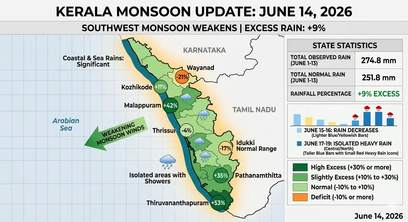
Monsoon 2026 : Southwest Monsoon Likely Before June 1; IMD Closely Tracks Key Parameters
One of the most anticipated weather events for Kerala is the arrival of the Southwest Monsoon, locally known as the Edavappathi.
Southwest Monsoon Likely Before June 1; IMD Closely Tracks Key Parameters
One of the most anticipated weather events for Kerala is the arrival of the Southwest Monsoon, locally known as the Edavappathi. Normally, the monsoon reaches Kerala around June 1. However, the India Meteorological Department (IMD) does not declare the onset of the monsoon merely because it starts raining. The announcement is made only after specific scientific criteria are satisfied.
To officially declare the onset of the monsoon over Kerala, three major conditions must be fulfilled simultaneously. These include rainfall distribution, wind patterns, and atmospheric cloud conditions.
1. Rainfall Criteria: The First Indicator
Rainfall is the primary requirement for declaring monsoon onset. After May 10, widespread rain activity must occur across selected stations in Kerala and the Lakshadweep region.
Out of 14 designated observation centres, at least 60 percent of the stations must record 2.5 mm or more rainfall for two consecutive days. In practical terms, this means at least 9 out of the 14 centres should receive this amount of rain. If this condition is met along with favourable atmospheric conditions, the IMD declares the onset of the monsoon on the second day.
Major Observation Centres
* Minicoy
* Amini
* Thiruvananthapuram
* Punalur
* Kollam
* Alappuzha
* Kottayam
* Kochi
* Thrissur
* Kozhikode
* Thalassery
* Kannur
* Kudlu (Kasaragod)
* Mangaluru
The spread and continuity of rainfall across these centres are considered extremely important.
2. Wind Pattern Analysis: Strength and Direction Matter
Rain alone is not enough for a monsoon declaration. Strong moisture-laden westerly winds from the Arabian Sea must penetrate the Indian subcontinent.
The westerly winds should extend up to the 600 hPa atmospheric level between the equator and 10°N latitude, and between 55°E and 80°E longitude.
This indicates that the monsoon circulation is active even in the upper atmosphere. Between 5°N and 10°N latitude and 70°E to 80°E longitude, wind speed at the 925 hPa level should be around 15 to 20 knots.
These strong winds transport moisture from the Arabian Sea to Kerala, triggering widespread rainfall. The IMD gathers this information using satellite observations, RSMC wind analysis, and weather models.
3. OLR Analysis: Confirming Cloud Formation
Another important parameter used in monsoon assessment is Outgoing Longwave Radiation (OLR).
OLR measures the amount of heat escaping from the Earth into space. When dense rain-bearing clouds develop, less heat escapes outward, causing OLR values to decrease.
Between 5°N and 10°N latitude and 70°E to 75°E longitude, the OLR value should fall below 200 W/m².Such low values indicate strong cloud development and active rainfall conditions in the region.These observations are mainly made using INSAT satellite data.
Why the Monsoon Declaration Matters
The onset of the monsoon over Kerala marks a crucial phase in India’s climate cycle. After reaching Kerala, the monsoon usually advances to Karnataka, Maharashtra, and northern India within the following weeks.
India’s agriculture, reservoirs, hydropower generation, drinking water availability, and overall economy are heavily dependent on the monsoon. That is why the onset date is closely watched across the country.
Normal Onset Date and Variations
Under normal conditions, the southwest monsoon reaches Kerala around June 1. However, atmospheric factors such as El Niño, La Niña, and variations in Indian Ocean temperatures, including the Indian Ocean Dipole (IOD), can influence the timing.
In some years the monsoon arrives early, while in others it may be delayed. Regardless of the timing, the IMD makes the official declaration only after all scientific criteria are satisfied.
വേനൽച്ചൂടിന് ആശ്വാസമായി യുഎഇയിൽ ശക്തമായ മഴ; ഖോർഫക്കാൻ മലനിരകളിൽ വിസ്മയമായി വെള്ളച്ചാട്ടം
കടുത്ത വേനൽച്ചൂടിൽ (Summer Heat) വലയുന്ന യുഎഇ നിവാസികൾക്ക് ആശ്വാസമായി UAEരാജ്യത്തിന്റെ കിഴക്കൻ മേഖലകളിൽ ശക്തമായ മഴ (Heavy Rainfall) പെയ്തു. മഴയെ തുടർന്ന് ജനപ്രിയ വിനോദസഞ്ചാര കേന്ദ്രമായ ഖോർഫക്കാൻ (Khorfakkan) മലനിരകളിലും ഫുജൈറ (Fujairah) പർവ്വതപ്രദേശങ്ങളിലും പ്രകൃതിദത്ത വെള്ളച്ചാട്ടങ്ങൾ (Natural Waterfalls) രൂപപ്പെട്ടത് പ്രദേശത്തെ അതീവ മനോഹരമാക്കി.
വെള്ളച്ചാട്ടങ്ങൾ കാണാൻ ജനത്തിരക്ക്
ഇന്ന് (ഞായറാഴച്ച) ഉച്ചയ്ക്കും വൈകുന്നേരത്തുമായി പെയ്ത ശക്തമായ മഴയിൽ മലമുകളിൽ നിന്നും ഒഴുകിയിറങ്ങിയ ജലധാരകൾ നിരവധി ഭാഗങ്ങളിൽ താൽക്കാലിക വെള്ളച്ചാട്ടങ്ങളായി മാറി. ഈ കാഴ്ച ആസ്വദിക്കാൻ കുടുംബങ്ങളോടൊപ്പം നിരവധി പേർ പ്രദേശങ്ങളിലേക്ക് ഒഴുകിയെത്തി.
കുട്ടികളും യുവാക്കളും വെള്ളച്ചാട്ടങ്ങൾക്കു സമീപം സമയം ചെലവഴിക്കുകയും ഒഴുകിയെത്തിയ ശുദ്ധജലത്തിൽ കളിച്ചും ആഘോഷിച്ചും മഴയെ വരവേൽക്കുകയും ചെയ്തു. സമൂഹമാധ്യമങ്ങളിലൂടെയും (Social Media) മഴയുടെ ദൃശ്യങ്ങൾ വ്യാപകമായി പ്രചരിക്കുകയാണ്.
ഫുജൈറ റോഡിൽ ഗതാഗത തടസം
ഫുജൈറയിലേക്കുള്ള പ്രധാന പാതയായ ഷെയ്ഖ് ഖലീഫ സ്ട്രീറ്റിന് (Sheikh Khalifa Street) സമീപമുള്ള പ്രദേശങ്ങളിൽ മഴ ശക്തമായതോടെ കാഴ്ചാപരിധി (Visibility) ഗണ്യമായി കുറഞ്ഞു. ശക്തമായ കാറ്റും മഴയും കാരണം ചിലയിടങ്ങളിൽ വാഹനഗതാഗതം മന്ദഗതിയിലാവുകയും യാത്രക്കാർ ജാഗ്രത പാലിക്കണമെന്ന് അധികൃതർ മുന്നറിയിപ്പ് നൽകുകയും ചെയ്തു.
റോഡുകളിൽ വെള്ളം കെട്ടിനിന്ന സാഹചര്യത്തിൽ വേഗത കുറച്ച് വാഹനമോടിക്കാനും മഴക്കാല സുരക്ഷാ നിർദേശങ്ങൾ പാലിക്കാനും ബന്ധപ്പെട്ട വകുപ്പുകൾ അഭ്യർഥിച്ചു.
മഴയുടെ ഫലമായി കിഴക്കൻ മേഖലകളിലെ നിരവധി വാദികൾ (Wadis) നിറഞ്ഞൊഴുകുകയാണ്. സാധാരണയായി വരണ്ടുകിടക്കുന്ന ഈ താഴ്വരകളിലൂടെ ശക്തമായ ജലപ്രവാഹം രൂപപ്പെട്ടത് പ്രദേശവാസികൾക്കും വിനോദസഞ്ചാരികൾക്കും കൗതുകമായി.
എന്നാൽ വാദികളിലേക്കും മലഞ്ചെരിവുകളിലേക്കും അനാവശ്യമായി ഇറങ്ങരുതെന്നും പെട്ടെന്നുള്ള വെള്ളപ്പാച്ചിലിന് (Flash Flood) സാധ്യതയുണ്ടെന്നും അധികൃതർ മുന്നറിയിപ്പ് നൽകി.
മൺസൂൺ സ്വാധീനത്തിന്റെ ഫലം
കാലാവസ്ഥാ വിദഗ്ധരുടെ വിലയിരുത്തൽ പ്രകാരം ഇന്ത്യയിൽ നിന്നുള്ള തെക്കുപടിഞ്ഞാറൻ മൺസൂണിന്റെ (Southwest Monsoon) സ്വാധീനവും അറബിക്കടലിൽ രൂപപ്പെട്ട ഈർപ്പസാന്നിധ്യവുമാണ് യുഎഇയുടെ കിഴക്കൻ മേഖലകളിൽ വേനൽക്കാല മഴയ്ക്ക് കാരണമായത്.
പ്രത്യേകിച്ച് ഒമാൻ ഉൾക്കടലിനോട് ചേർന്ന പർവ്വതപ്രദേശങ്ങളിൽ മേഘസാന്ദ്രത വർധിച്ചതോടെ ഇടിമിന്നലോടുകൂടിയ മഴ ലഭിക്കുകയായിരുന്നു. രാജ്യത്തിന്റെ മറ്റ് ചില ഭാഗങ്ങളിലും കാർമേഘങ്ങൾ രൂപപ്പെടുകയും നേരിയ മഴ രേഖപ്പെടുത്തുകയും ചെയ്തു.
റെക്കോർഡ് മഴയ്ക്ക് ശേഷമുള്ള പ്രധാന വേനൽമഴ
സമീപകാലത്ത് രേഖപ്പെടുത്തിയ റെക്കോർഡ് മഴയ്ക്ക് (Record Rainfall) ശേഷം ലഭിക്കുന്ന പ്രധാന വേനൽമഴയായാണ് ഇതിനെ വിലയിരുത്തുന്നത്. മുമ്പ് അൽ തവിയീൻ (Al Tawyeen), അൽ മർജാൻ (Al Marjan), ഖോർഫക്കാൻ മേഖലകളിൽ കനത്ത മഴ ലഭിച്ചതിനെ തുടർന്ന് റോഡുകളിൽ വെള്ളക്കെട്ടും ഗതാഗത തടസവും രൂപപ്പെട്ടിരുന്നു.
പ്രവാസികൾക്കും സ്വദേശികൾക്കും ആശ്വാസം
ദിവസങ്ങളായി 40 ഡിഗ്രി സെൽഷ്യസിന് മുകളിലുള്ള താപനില അനുഭവപ്പെട്ടിരുന്ന സാഹചര്യത്തിൽ ഈ അപ്രതീക്ഷിത മഴ പ്രവാസികൾക്കും സ്വദേശികൾക്കും ഒരുപോലെ ആശ്വാസമായി. മഴയെത്തുടർന്ന് പല പ്രദേശങ്ങളിലും അന്തരീക്ഷ താപനില കുറയുകയും ശീതളമായ കാലാവസ്ഥ അനുഭവപ്പെടുകയും ചെയ്തു.
വേനൽച്ചൂടിൽ നിന്ന് താൽക്കാലിക മോചനം സമ്മാനിച്ച ഈ മഴയും മലനിരകളിൽ രൂപപ്പെട്ട മനോഹരമായ വെള്ളച്ചാട്ടങ്ങളും യുഎഇയുടെ കിഴക്കൻ മേഖലകളെ വീണ്ടും പ്രകൃതി സൗന്ദര്യത്തിന്റെ കേന്ദ്രമാക്കി മാറ്റിയിരിക്കുകയാണ്.
English Summary : Heavy rainfall lashed the eastern regions of the UAE, including Khorfakkan and Fujairah, bringing much-needed relief from the scorching summer temperatures that had been soaring above 40°C.