Weather Alert : PAN INDIA WEATHER & SOUTHWEST MONSOON UPDATE
The last week of July witnessed another active spell of the Southwest Monsoon across large parts of Central and Western India.
PAN INDIA WEATHER & SOUTHWEST MONSOON UPDATE @ 5:09 hrs on 1/8/26.
Weekly Outlook: 1 st to – 07th August 2026 and extended forecast for 2-3 more days.
🇮🇳 PAN INDIA WEATHER SNAPSHOT
The last week of July witnessed another active spell of the Southwest Monsoon across large parts of Central and Western India. A well-marked monsoon depression that originated over the Head Bay of Bengal moved inland across eastern and central India, producing widespread extremely heavy rainfall over several north India, states and significantly enhancing the monsoon circulation.
The seasonal monsoon trough remained active as its south eastern end shifted more to the south while the west coast offshore trough continued to support moderate rainfall along the Konkan–Malabar coast.
On the whole the sustained rains towards the latter half of July over the north west, central and eastern states has helped reduce the country's rainfall deficit substantially. .
🌧️ RAINFALL HIGHLIGHTS
🌴 Kerala & Mahe
Kerala continued to receive intermittent monsoon showers with heavier spells along the windward slopes of the Western Ghats, the central midland region and the Malabar coast. Despite recent improvements, cumulative seasonal rainfall remains below normal over several districts.
🌊 Coastal Karnataka & Konkan
Moderate to locally heavy rainfall continued, particularly along the coastal belt.
Though Tamil Nadu lies on the leeward side of the western ghats and hence technically in the rain shadow region, certsin pockets do get moderate to heavy isolated rain due to the peculiar thermodynamics involved .
During the Southwest Monsoon, the strong zonal winds hit the Western Ghats. As the air descends on the eastern leeward side (Tamil Nadu), it undergoes adiabatic compression.
The Mechanism: Sinking air compresses and warms at the dry adiabatic lapse rate ((9.8°C/km)
Result: This clears the sky, suppresses large-scale monsoon cloud cover, and leads to intense solar insolation.
Thermodynamics: The land surface heats up rapidly, creating a deep, highly unstable convective boundary layer. Ground temperatures frequently breach 35 to 40°C.
2. Moisture Advection via Sea Breezes
Despite the dry sinking air from the mountains, Tamil Nadu is flanked by the Bay of Bengal to the east.
The Trigger: Intense daytime heating over the land creates a localized low-pressure zone.
Moisture Influx: This temperature gradient forces a strong, moisture-rich sea breeze to penetrate inland during the afternoon.
The Mixing: This low-level maritime moisture gets trapped beneath the hot, dry air mass aloft, creating high Convective Available Potential Energy (CAPE).
3. Boundary Layer Convergence and Low-Level Jets
The physics of the storm initiation relies on mechanical lifting to break the convective inhibition (CIN).
Wind Shear Convergence: The strong westerly/southwesterly monsoon winds overshooting the Ghats collide with the easterly sea breeze over the interior plains.
Vertical Velocity: This low-level wind convergence forces the warm, humid air sharply upward.
Thermodynamic Lift: The lifted air parcels quickly reach their Level of Free Convection (LFC), transitioning into violent updrafts.
4. Upper-Tropospheric Instability and Moisture Recycling
The vertical structure of the atmosphere during this season further amplifies the severity of these thundershowers.
High CAPE & Low CIN: Extreme thermal heating maximizes CAPE (often exceeding (2000 J/kg) while the sea breeze convergence easily breaks the capping inversion leading yo isolated high intensity thundershowers of short duration.
The passage of the monsoon depression resulted in very heavy rainfall across south eastern and central Gujarat, with several districts under the grip of flood.
Monsoon activity remained extremely vigorous over much of the state.
Heavy rainfall affected:
and adjoining districts continued to receive massive rains.
Widespread heavy rainfall continued under the influence of the monsoon depression passing through the state.
The region experienced one of its wettest spells of the season as the depression tracked northwestward.
Heavy rainfall occurred across several districts with locally intense thunderstorms in Hyderabad, Ramagundam and adjoining districts.
Frequent moderate to heavy rainfall continued, providing further relief to the seasonal deficit.
Punjab, Haryana and parts of Rajasthan and the NCR Delhi received moderate to heavy rainfall, while isolated heavy spells continued over the Himalayan foothills.
🌧️ North- east India
The north eastern region continues to suffer deficit rainfall with Meghalaya region reporting a deficit above 50%. As already analysed in one of earlier weekly post ,
large-scale atmospheric analysis indicates that the Western Pacific Subtropical High (Philippines High) has remained stronger than normal during much of the current monsoon season. Its westward extension has curtailed deep convection over the Bay of Bengal, reducing the frequency of monsoon lows and depressions. Consequently, moisture transport into northeast India has remained below normal, contributing significantly to the ongoing rainfall deficit across the region. This feature continues to be monitored as a key large-scale driver of the 2026 southwest monsoon.
📊 MONSOON PERFORMANCE
Although July ended with a noticeable improvement in rainfall over Central India, the seasonal distribution remains uneven.
Most subdivisions across Central India have benefited from repeated Bay of Bengal systems.
However, rainfall deficits continue over:
🔸 Bihar (localized)
🔸 Several districts of Northeast India, especially Meghalaya and adjoining areas.
The persistent deficit over Northeast India is particularly alarming.
As already analysed the deficit in the north north- is a combination of the following:
• The developing El Niño background, which can gradually weaken the Walker Circulation.
• A westward extension of the Western North Pacific Subtropical High, associated with a Pacific–Japan (PJ) circulation pattern that may suppress convection over the Philippine Sea and alter moisture transport toward Northeast India.
• Intraseasonal variability in the monsoon circulation and local topographic effects.
Rather than a single cause, the rainfall anomaly is likely the result of these factors acting together.
The mid July turnaround in the monsoon rains from a big deficit of over 45% to 13% has proved the IMD predictions wrong. IMD had predicted a shortfall of over 90% for July monsoon rainfall.
Blindly going by a ELNino signals can no longer account for the peculiar monsoon behaviour in Indian conditions of 2026. Probably the trend towards positive IOD from mid July could be one of the reasons that may have offset the impact of ELNino. But that is only one of the variables and it cannot have caused this dramatic turnaround in July rainfall. Researchers need to delve more deeply into the equatorial western Pacific dynamics to find out what exactly is causing the unexpected changes in spatial distribution of monsoon rains in spite of a confirmed ELNino season.
🌡️ TEMPERATURE UPDATE
Persistent cloudiness maintained comfortable temperatures across much of north Indian hillstations Central and in the hillstations in the south.
Monsoon Cooling: Because it is the peak of the southwest monsoon season across India, the maximum temperatures have dropped significantly compared to the dry summer months.
Narrow Temperature Diurnal Range: Due to heavy cloud cover and moisture, the gap between the day's maximum and the night's minimum is very narrow (often only 3°C to 5°C apart), especially in northern hill stations like Gulmarg.
Details of various temperature recorded at hillstations/ tourist stations are given below
Region / State/Hill Station/Maximum /Minimum & Weather Conditions.
Heavy rain & thunderstorms
Mostly cloudy with showers
Passing rain showers
Constant monsoon overcast
Rain and thunderstorms
Mostly cloudy & pleasant
Chilly, overcast with drizzle
Cloudy with continuous drizzle
Humid with thunderstorms
Continuous light rain
Rain/Cold (High Altitude)
Very cold, near freezing wind chill
Extreme cold, risk of sleet
Shillong (Meghalaya)
Monsoon thunderstorms
Heavy rainy intervals
Darjeeling( Sub Himalayan West Bengal)
Heavy rain over hills
Thunderstorms possible
Kanthalloor.( Rain shadow region)
Cloudy, & chilly at times & pleasant generally.
Cool, overcast (Rain Shadow)
Warm day, humid showers
Chilly winds and mist
Kodaikanal (Tamil Nadu)
Cool and foggy spells but generally sunny
Partly cloudy, warmer intervals
Constant monsoon drizzle
(31 July – 06 August)
🌬️ 850 hPa Wind Field
A broad belt of strong southwesterly monsoon winds is expected to persist across the Arabian Sea and Peninsular India. The monsoon low level Somali jet has gained substantial momentum off the east African coast and has caused injection of massive moisture transport into the Arabian sea.
Enhanced moisture transport should continue into Central India, while periodic strengthening of the Bay branch will sustain rainfall over eastern India.
The atmosphere is almost aligned in similar conditions as in the last week with strong lower level westerlies and a depression in the BoB likely to develop by 5 th August.
🌪️ 200 hPa Wind Field
The Tropical Easterly Jet remains well established south of the Himalayas.
Upper-level analyses continue to indicate favourable divergence over Central and Eastern India, supporting sustained convective development.
The seasonal monsoon trough is expected to remain active across northern India with embedded cyclonic circulations enhancing rainfall over the Indo-Gangetic Plains.
The west coast offshore trough from Gujarat to the Malabar coast is expected to remain active, maintaining moderate to occasionally heavy rainfall along the west coast.
🌀 Bay of Bengal Outlook
Forecast guidance indicates the possibility of another low-pressure area developing over the head Bay of Bengal around 5 August.
If the system strengthens, it could trigger another bout of heavy rainfall over:
🌧️ Eastern Uttar Pradesh
before heading north westward
🌍 GLOBAL OCEAN–ATMOSPHERE UPDATE
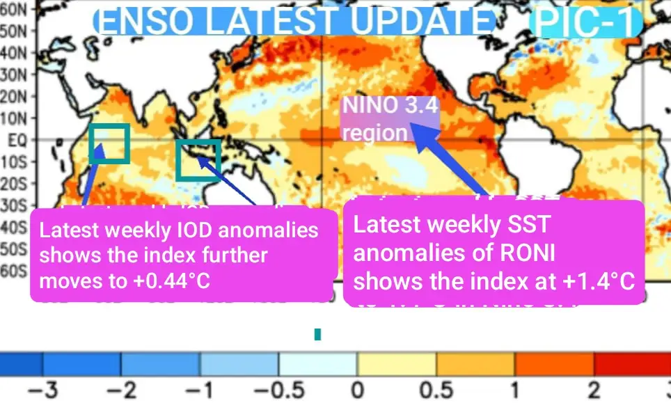
The tropical Pacific continues its transition toward El Niño conditions. Oceanic warming remains evident across the central equatorial Pacific, while atmospheric coupling is becoming more apparent. The latest weekly SST anomalies and RONI continued to maintain its upward trend and is currently at +1.4°C.
Indian Ocean Dipole (IOD)
The IOD too maintained positive anomalies , with recent values at +0.44°C. ( See pic-1).
The positive IOD, if sustained, may partly offset some of the suppressive influence of the developing El Niño on the Indian monsoon during August.
🌊 MADDEN–JULIAN OSCILLATION (MJO)
The MJO is currently spanning the western hemisphere in Phase 8 and remains relatively weak with modest amplitude and is not expected to dominate monsoon variability during the coming week. The upper level velocity potential values point to convergence aloft and a dry phase to cover the Indian Ocean from the beginning of second week of August. Synoptic-scale Bay of Bengal systems are likely to remain the primary drivers of rainfall distribution.
The MOPI framework continues to indicate a generally favourable large-scale monsoon environment.
Positive contributors include:
✅ Strong Tropical Easterly Jet.
✅ Active monsoon trough.
✅ Sustained low-level southwesterlies.
✅ Weakly positive Indian Ocean Dipole.
✅ Recurrent Bay of Bengal synoptic systems.
Areas requiring continued monitoring include:
⚠️ Persistent rainfall deficits over Northeast India.
⚠️ Below-normal rainfall over parts of Kerala.
⚠️ The strengthening El Niño signal and its evolving influence during August.
🌧️ REGIONS MOST LIKELY TO RECEIVE HEAVY RAINFALL In NEXT 2-3 DAYS
The heaviest rainfall during the coming week is expected over:
🌧️ COASTAL ANDHRA PRADESH
🌧️ Konkan & Goa
🌧️ Coastal Karnataka
🌧️ Parts of the Western Himalayan foothills
Very heavy rainfall is also expected across the coastal and eastern high ranges of Kerala on 1st & 2 nd August and the Northeast from 1st to 4th August.
(Next weekly update between 8 and 10 August)
— Kerala Weather Man 🌧️🇮🇳
മധ്യ കേരളത്തിൽ വിവിധ പ്രദേശങ്ങളിൽ കനത്ത മഴ തുടരുന്നു. താഴെപ്പറയുന്ന പ്രദേശങ്ങളിൽ പുലർച്ച വരെ മഴ തുടരാൻ സാധ്യതയുണ്ടെന്നാണ് നിഗമനം.
എറണാകുളം, കോട്ടയം, പെരുമ്പാവൂര്, തൃപ്പൂണിത്തുറ, കോലഞ്ചേരി, ആലുവ, ചീരാല്, അങ്കമാലി, ആലപ്പുഴ, മൂന്നാര്, മുട്ടം, ഈരാറ്റുപേട്ട, വൈക്കം,തലയോലപറമ്പ്, നേര്യമംഗലം, കോലഞ്ചേരി, അടിമാലി, അഞ്ചല്, ഏറ്റുമാനൂര്, കല്ലറ, മേഖലകളില് പുലര്ച്ചെ വരെ ശക്തമായ മഴ തുടരാന് സാധ്യത. കോഴിക്കോട് തെക്ക്, തൃശൂര്, മലപ്പുറം ജില്ലകളില് നിലവില് മഴ വിട്ടു നില്ക്കുന്നുണ്ടെങ്കിലും രാത്രി 10.30 ന് ശേഷം ഒറ്റപ്പെട്ട ശക്തമായ മഴയ്ക്കു സാധ്യതയുള്ളത്.
English Summary : Heavy Rain Continues Across Central Kerala; Nighttime Showers Forecasted Until Dawn. Key Affected Areas: Regions likely to see continued strong rainfall overnight include Ernakulam, Kottayam, Perumbavoor, Tripunithura, Kolenchery, Aluva, Cheeral, Angamaly, Alappuzha, Munnar, Muttom, Erattupetta, Vaikom, Thalayolaparambu, Neryamangalam, Adimali, Anchal, Ettumanoor, and Kallara.